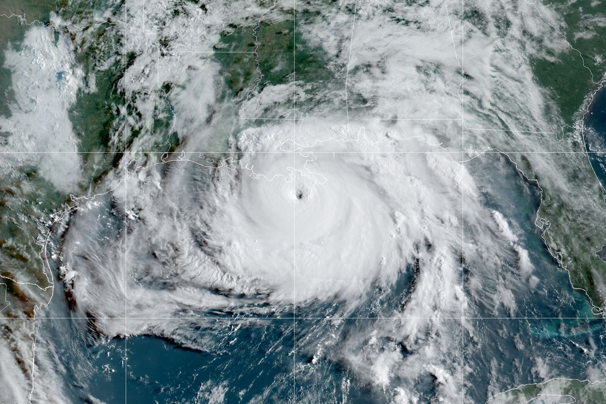
Ida roared ashore in southeastern Louisiana on Sunday as a category 4 hurricane, bringing several feet of storm surge flooding and extreme winds that are crushing the Gulf Coast, according to reporting from the Weather Channel.
Reports continue to trickle out of Grand Isle, Louisiana, detailing the disastrous conditions there, where water is covering roads and emergency services buildings are flooded.
“We have gotten requests for rescue for people who stayed on the island,” Parish President Cynthia Lee Sheng said in a news briefing Sunday afternoon. “I mentioned white caps are on the highway, our fire station is taking water, obviously first responders cannot get to you so those folks are just going to have to hunker down.â€
Mandatory evacuations were issued in Grand Isle, which is located in Jefferson Parish, but there were reports that several people stayed behind. Police Chief Scooter Resweber said about 15 people who didn’t evacuate were sheltering at the police station.
Resweber described the scene there as Ida neared landfall and he and others with him watched out the bulletproof window of a hardened police bunker.
“We’re watching the roofs peel off buildings next to us. The flooding is catastrophic,” Resweber told The Weather Channel in a phone call. “We’re in bad, dire shape.”
Ida officially made landfall at 11:55 a.m. CDT near Port Fourchon, Louisiana, about 18 miles southwest of Grand Isle and about 60 miles south of New Orleans. Maximum sustained winds were 150 mph, making Ida a high-end Category 4.
A rare extreme wind warning was issued ahead of the storm for those first up in Ida’s path. The National Weather Service warned: “This is an extremely dangerous and life-threatening situation!”
Resweber said a wind gauge at the police station measured 148 mph. And then the gauge broke.
“Things are coming apart all around us,” he said.
Cameras in Grand Isle as Ida’s outer bands moved in Sunday morning showed the earth had been transformed by storm surge into a turbulent ocean. The only road in and out was enveloped. The storm’s winds pushed the water against stilted houses and formed raging whitecaps.
The cameras were later knocked out by the storm surge.
Here’s the latest from the storm’s path:
Louisiana
-More than 319,000 homes and businesses were without power in Louisiana as of about 2:30 p.m. CDT, according to poweroutage.us.
-Downed power lines and trees were reported across the southeastern Louisiana. Officials in Jefferson Parish said most of the outages there – about 107,000 – were caused by down trees.
-Video from St. Bernard Parish, southeast of New Orleans, showed water rushing in.
-New Orleans has suspended EMS service until it is safe to resume. “We are at this point,” Tyrell Morris, the city’s 911 director, said in a news conference early Sunday afternoon. “All the public safety agencies at this point are making decisions of when they will or will not respond.†The 911 system was down for about 10 minutes earlier in the day, Morris said.
-New Orleans Mayor LaToya Cantrell told those who remain in the city to stay off the streets. “All of our residents, even visitors who are here, this is the time to stay inside,” Cantrell said. “Don’t venture out, no sightseeing, this is very dangerous. We need to stay in from this point forward, all morning, all afternoon, all evening.â€
-Over 6 feet of storm surge was reported in Shell Beach, Louisiana, and Waveland, Mississippi. Two feet was reported on Dauphin Island, Alabama.
-Gusts of over 120 mph were reported at an elevated weather station.
-Hospitals were already filled to capacity in some areas due to COVID-19 so officials told people not to go to emergency rooms unless they have a life-threatening situation and warned them to take precautions after the storm to avoid preventable death and injury that would stress hospitals further.
Mississippi
-Curfews are in place in Hancock and Harrison counties.
-Parts of U.S. 90 were closed due to flooding in Hancock County, according to the Biloxi Sun Herald.
-Flooding was reported in casino parking garages.
Levees Could Overtop
Ida threatened to overtop some levees in the New Orleans area designed to do just that.
Feet of storm surge was already reported on Shell Beach, Louisiana, early Sunday morning and the National Hurricane Center bumped its projected storm surge totals to 12 to 16 feet along parts of the southeast Louisiana coast.
The U.S. Army Corps of Engineers (USACE) told NOLA.com that some levees located along the west bank of the Mississippi River, in Jefferson Parish, could be overtopped by storm surge, but emphasized that the levees should hold up and that was most important.
“It’s a different system than we had in Katrina. By it being designed to be overtopped, we won’t have the erosion and the scouring that leads to breaching,†USACE spokesperson Ricky Boyett told Nola.com. “Once that water recedes you’ll still have a levee there. There’s a big difference between a breach where water is running uncontrolled into an area and water coming over the top for a brief period of time.â€
Given the location of the levees further inland, it remained to be seen whether or not surge levels there would hit heights capable of overtopping them. The USACE commented on the situation Saturday before surge level projections were increased to up to 16 feet.
Infrastructure in Lafourche and Terrebonne parishes will be worse off.
In an interview with 4WWL, USACE representative Heath Jones said that flood infrastructure there was “not designed for this level.”
“They may have some issues down there in Terrebonne and Lafourche parish. Follow the local leaders’ advice,” Jones said.


